ENGINEERING
& ENERGY
TUNNELING
& ARCHITECTURE
& OFFSHORE
Where We Excel
Industries We 3D Laser Scan & Measure Using Laser Trackers
Reverse
Engineering
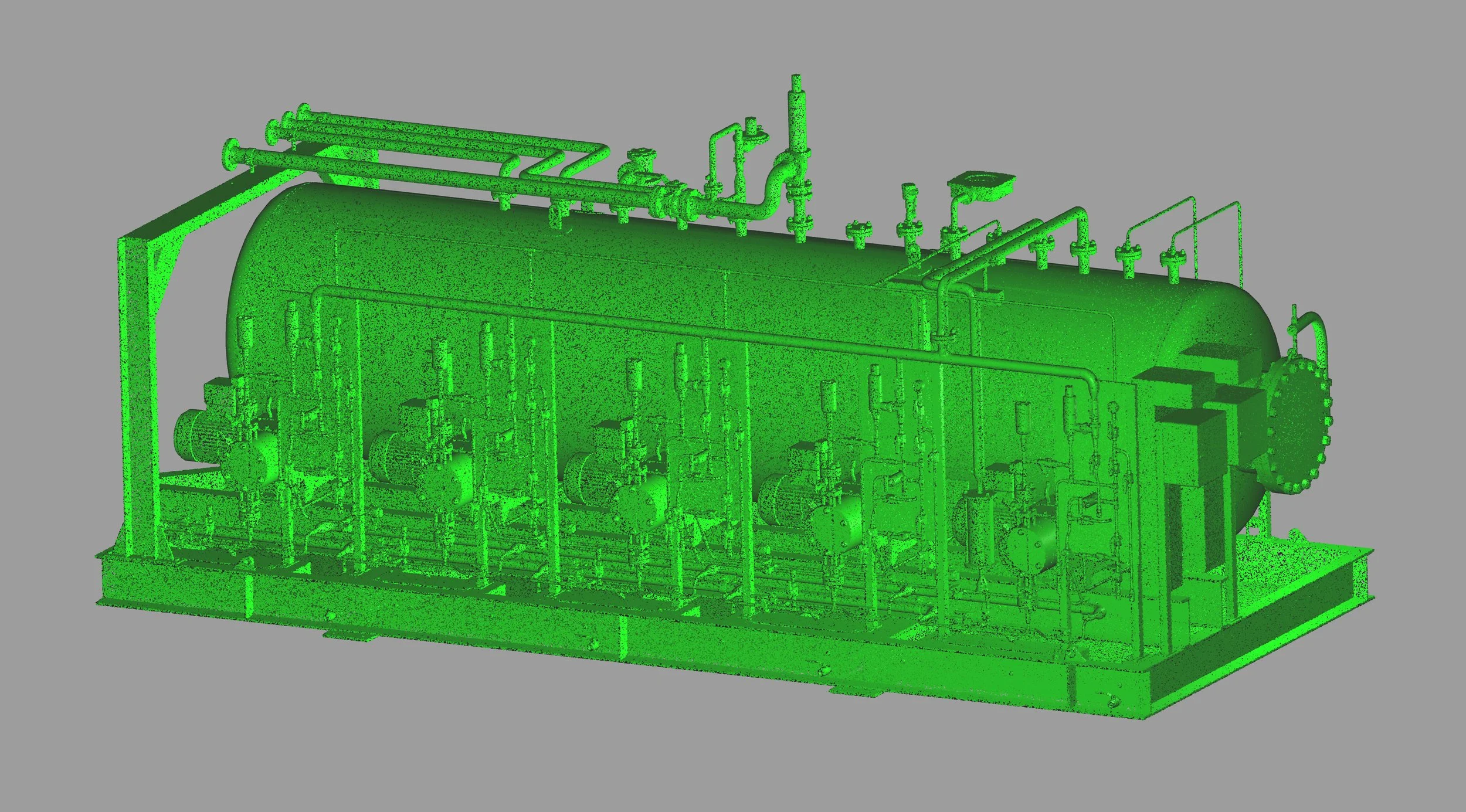
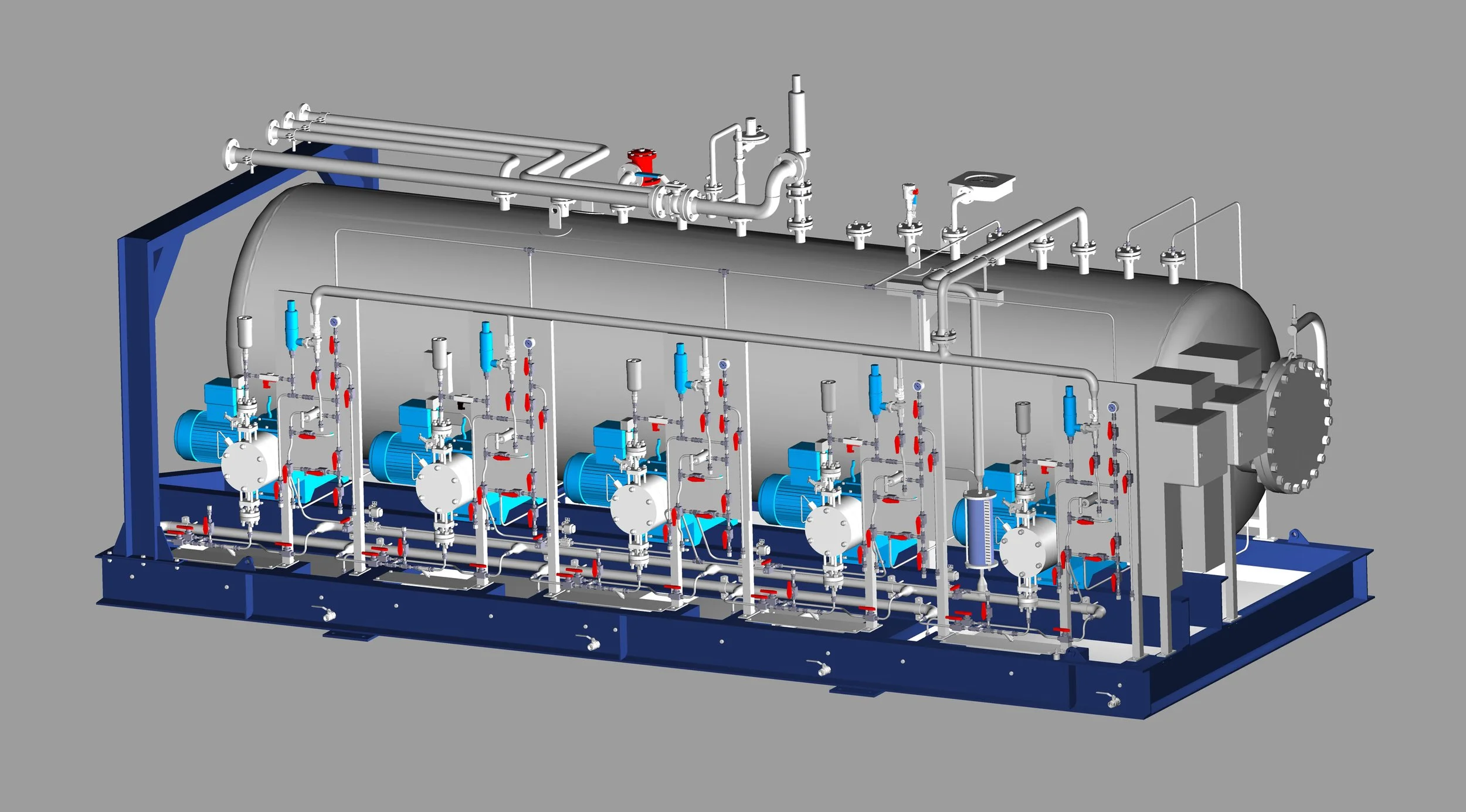
Rebuild complex components as accurate as-built 2D & 3D CAD models from 3D laser scan data.
Industry
& Energy
Accurately document complex industrial facilities in 3D to streamline engineering operations.
Mining
& Tunneling
Model mining and tunneling operations in 3D to coordinate layouts, expansions, and critical infrastructure.
Civil Engineering
& Architecture
Create precise as-built 2D & 3D documentation to support accurate planning, design, and construction.
Marine
& Offshore
Produce accurate 2D & 3D as-built models of vessels and offshore assets for critical engineering processes.
ABOUT US
When Accuracy Matters
PT SURYA KWON SUNG (PT SKS) is a leading service provider in 3D laser scanning, laser tracker measurement, dimensional inspection, and as-built 3D modeling in Indonesia. Above all else, we prioritize measurement precision and efficiency by leveraging the latest equipment and a comprehensive software suite. Experience unparalleled accuracy in every dimension with us.
WE ARE A HEXAGON DISTRIBUTOR
Elevate manufacturing precision, productivity, and quality with PT SURYA KWON SUNG—your authorised Hexagon Manufacturing Intelligence partner in Indonesia.
Exceptionally Accurate
Our As-Built Products
REGISTERED POINT
CLOUDS
For clients who prefer to do their own post point cloud data processing, we offer registered colored or black & white point clouds.
3D MESH
MODELS
Scan to Mesh: We provide a wide range of as-built point cloud to 3D mesh model conversions in various mesh model file formats.
3D CAD
MODELS
Scan to CAD: We offer highly accurate as-built point cloud to 3D CAD model conversions in multiple formats.
BIM
MODELS
Scan to BIM: We deliver a variety of as-built point cloud to BIM (Building Information Modeling) model conversions.
PLANT DESIGN
MODELS
Scan to Plant: We provide as-built point cloud conversions into detailed plant design models and piping isometric drawings.
LASER TRACKER ALIGNMENT
& INSPECTION
For machinery alignment and inspection, where accuracy is critical, we utilize laser tracker CMMs, measuring arm CMMs, and metrology-grade handheld 3D laser scanners.
STORAGE TANK INSPECTION
& CALIBRATION
Using 3D laser scanning, we create accurate storage tank inspection and calibration reports for both aboveground and underground storage tanks.
VOLUME
SURVEYS
With 3D laser scanning, we perform highly accurate and efficient volumetric surveys, often employed in storage tanks, ship ballast & fuel tanks, and stockpiles.
2D CAD
DOCUMENTATION
We offer a variety of as-built 2D CAD documentations including but not limited to engineering, architectural, and inspection drawings.
CONSTRUCTION
VERIFICATION
By comparing design models to point clouds or point clouds to each other we provide clash detection analysis and construction verification.
DEFORMATION
& WEAR ANALYSIS
Using 3D laser scanning and/or CMM measurements, we create 3D color map models for deformation and wear analysis.
TOPOGRAPHIC MAPPING & GEOREFERENCING
Utilizing 3D laser scanning, we generate 2D & 3D topographic models. Additionally, with GNSS RTK rovers we georeference point clouds, BIM & plant design models, and GPR data.
GPR (UNDERGROUND
MAPPING)
Our ground penetrating radar (GPR) enables us to provide underground mapping services to produce both 2D & 3D data.
PROPELLER
INSPECTION
3D laser scanning with TrueProp Software allows for highly fast and accurate propeller inspections following ISO 484 tolerance standards.
VR/AR & 3D
DIGITAL CONTENT
By employing 3D laser scanning, we convert real-world objects and environments into digital 3D models for applications such as virtual reality (VR), augmented reality (AR), & 3D digital content.
Authorised Hexagon Distributor
Shop Hexagon Equipment
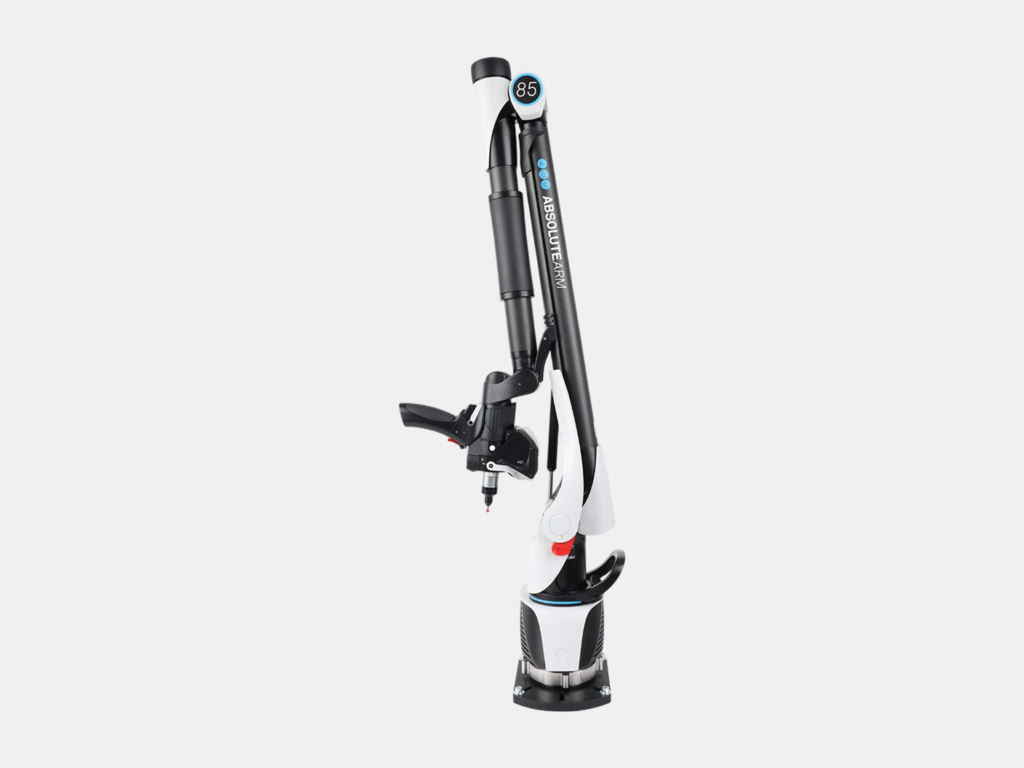
Portable Measuring Arms
Portable probing & 3D laser scanning for small-to-medium sized parts.
Laser Tracker Systems
Portable probing & 3D laser scanning for medium-to-ultra large sized parts.
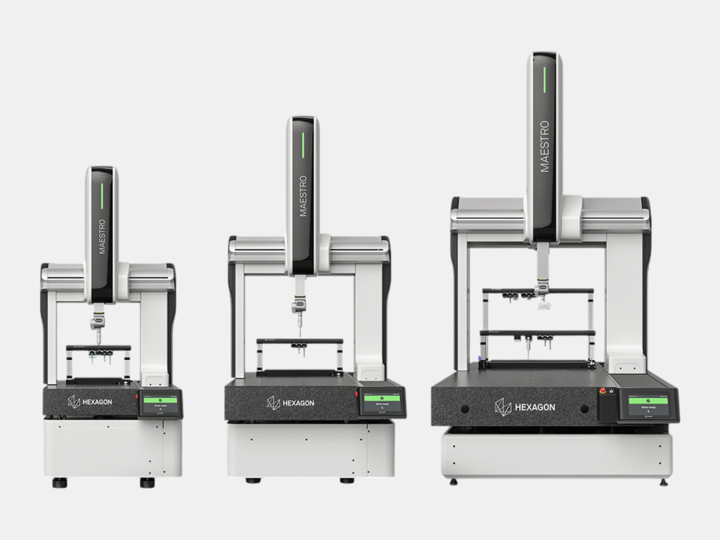
Coordinate Measuring Machines (CMMs)
Fixed ultra-high accuracy probing & 3D scanning for small-to-large sized parts.
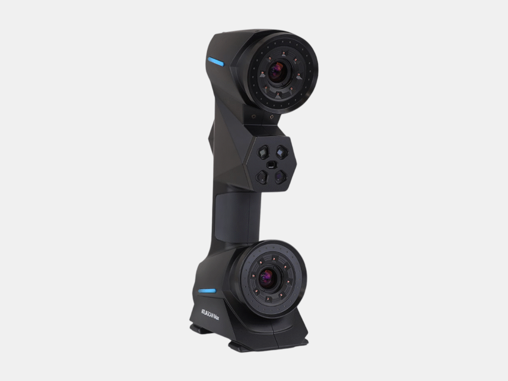
Handheld 3D Laser Scanners
Portable and flexible 3D laser scanning for small-to-medium sized parts.
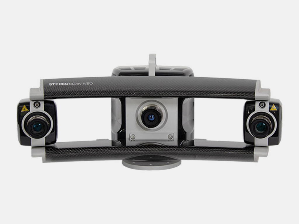
Structured Light Scanners
Portable high accuracy 3D laser scanning for small-to-medium sized parts.
Metrology Software
Comprehensive suite of metrology software including for reverse engineering, inspection, and design.
As-Built Modeling
Scan To CAD - From Accurate Point Cloud to Precise CAD Models
OURCLIENTS
We have partnered with clients across a diverse range of industries including petrochemical, defense, mining, manufacturing, and civil engineering.
We have partnered with clients across a diverse range of industries including petrochemical, defense, mining, manufacturing, and civil engineering.
OUR CLIENTS
We have partnered with clients across a diverse range of industries including petrochemical, defense, mining, manufacturing, and civil engineering.


Exceptionally Accurate
Learn More About
Unrivaled Efficiency
What is Terrestrial 3D Laser Scanning
Terrestrial 3D laser scanning is an advanced reality-capture method for surveying medium to large assets with speed and accuracy. A tripod-mounted 3D laser scanner captures millions to billions of accurate 3D points—each with X, Y, and Z coordinates—to form a highly detailed point cloud of the environment. This point cloud becomes a reliable foundation for accurate as-built 2D drawings and 3D CAD models, inspection and analysis, visualization, and high-fidelity digital twins.
01
Accuracy
Millimeter accuracy for reliable measurements of medium to large assets.
02
Speed & Coverage
Capture millions of points per second for fast, comprehensive documentation.
03
Cost Savings
Reduce rework, change orders, and repeat site visits with complete, data-rich capture.
04
Safety
Capture from up to 130 m away, keeping personnel clear of hazards.
Unmatched Flexibility
What is Handheld 3D Laser Scanning
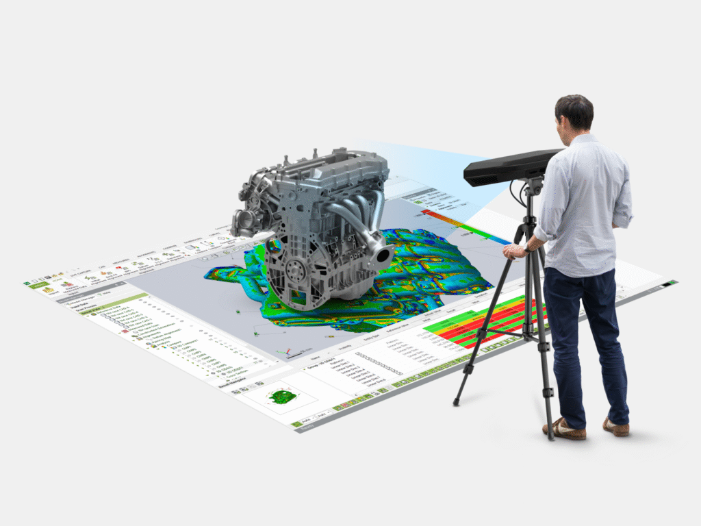
Handheld 3D laser scanning is a portable, high-detail measurement method that uses a high-accuracy 3D laser scanner to capture the exact shape of small to medium sized objects. By moving the 3D laser scanner around the part, it records dense 3D data and generates an accurate digital model for inspection and reverse engineering. With accuracy of up to 0.02 mm, handheld scanning is ideal for complex geometry, tight spaces, and components that require fine detail.
01
Accuracy
Up to 0.02 mm accuracy for accurate measurement of small to medium objects.
02
High Detail
Captures fine features and complex geometry for inspection and reverse engineering.
03
Speed
Fast capture with minimal setup—ideal for rapid inspection and short turnaround projects.
04
Flexibility
3D Scan in tight spaces and on-site conditions where tripod setups are impossible or slow.
Unparalleled Accuracy
What is Laser Tracker Measurement
Laser tracker measurement is a metrology-grade solution for high-accuracy probing, alignment, and dimensional inspection—ranging from small parts to large assemblies. A laser tracker measures 3D coordinates in real time by tracking a reflector or probe, making it ideal for critical tolerance checks, installation alignment, tooling verification, and quality control. With probing accuracy of up to 0.015 mm, it delivers confidence for the most demanding measurement tasks.
01
Accuracy
Probing accuracy up to 0.015 mm for critical inspection of small to large objects.
02
Large-Scale Capability
Measure small to large objects and assemblies while maintaining high accuracy.
03
Real-Time Alignment
Instant feedback for faster alignment, assembly guidance, and corrective adjustments.
04
Traceable QA/QC
Clear measurement results and reporting to support quality documentation and compliance.
Industry Leading
Our Equipment Features Best-In-Class Hardware & Software


